SDG11
Permanent Exhibition Update at Fort Zeelandia Museum: NCKU Guides Visitors Through 400 Years, from Tayouan to Taiwan

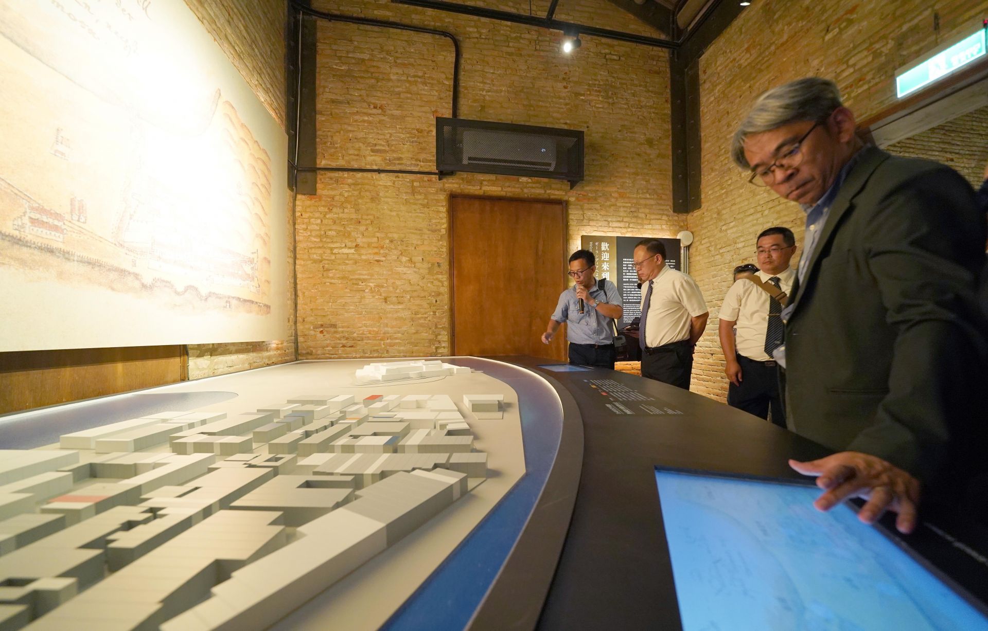
400 years ago, the Dutch established Fort Zeelandia and a township in Formosa (present-day Taiwan), marking the beginning of the development of Tainan's Anping settlement and the history of Tainan. During that time, what did Tainan look like? The Tainan City Government Cultural Affairs Bureau, in collaboration with NCKU, unveiled the updated permanent exhibition at the Fort Zeelandia Museum on September 23. One of its features is the integration of interactive installations and multimedia technologies, showcasing research results from various units, including the Department of Architecture, Institute of Archaeology, and the NCKU Museum.
Minister of Culture, Che Shih, attended the opening ceremony of the updated permanent exhibition at the Fort Zeelandia Museum. Other attendees included NCKU Vice President and Museum Director Bing-Sheng Wu, Museum Deputy Director Wen-Sung Chen, Professor Yi-Chang Liu of the Institute of Archaeology, and Associate Professor En-Yu Huang from the Department of Architecture. After the opening ceremony, Che Shih and other dignitaries toured the indoor and outdoor exhibitions, using augmented reality (AR) to witness the appearance of Fort Zeelandia and the township 400 years ago. They also listened to explanations from Associate Professor En-Yu Huang while comparing the historical sites with present-day Anping.
Originally focused on the architectural history of South and Southeast Asia, Associate Professor Huang's interest in Fort Zeelandia was sparked in 2016 when he learned about the accidental discovery of the 1643 "Register of Real Estate in the Township of Fort Zeelandia" manuscript. This led him to delve into the reconstruction research of Fort Zeelandia's spatial layout. What started as a side project became increasingly intriguing, expanding into the reconstruction of Fort Zeelandia's architecture and other related studies, continuing to the present day.
According to Associate Professor Huang, the research team utilized historical documents such as the 1643 "Register of Real Estate in the Township of Fort Zeelandia," "Fort Zeelandia Diary," "Reports of the Dutch East India Company," "Grand Council Resolutions," and "Letters from the Governor of Taiwan to the Governor-General of Batavia." They also referenced various maps and architectural images from the Dutch colonial period, conducted on-site surveys in Anping, and visited Indonesia and the Netherlands to examine 17th-century architectural remains and spatial textures. After more than five years of effort, they successfully reconstructed the 17th-century layout and virtual model of Fort Zeelandia and the township.
Associate Professor Huang emphasized the challenges of the research, as the historical documents related to Fort Zeelandia were fragmentary and intricate. Additionally, the terminology for Dutch architecture in the 17th century varied, and the meanings of different architectural terms changed over time. Continuous discussions and consultations with scholars from the Academia Sinica and the Netherlands were necessary, even requiring visits to the Netherlands to gather clues. He shared a self-made "Explanation Table of Fort Zeelandia's Form, Structure, and Dimensions," stating that it took about half a year to create this concise document.
The development of Fort Zeelandia and the township in Anping reflected many traditional features of Dutch towns, such as the "grid pattern" spatial planning. According to Associate Professor Huang, this pattern originated from the flat terrain and the historical use of grid planning in polder areas since the late Middle Ages. The grid pattern is still recognizable within the original boundaries of the Fort Zeelandia township, while the spatial development beyond this area after the end of the Dutch colonial period is characterized by winding streets. Additionally, historical maps indicate that the Dutch, in efforts to reduce typhoon damage, constructed artificial shorelines using wooden stakes and stones and built canals in the township, reflecting the Dutch tradition of coexisting and resisting water.
The flourishing development of Fort Zeelandia township expanded from initially six blocks to 23 blocks. The township included businesses, blacksmith workshops, hospitals, a prison, and a cemetery. The 1643 "Register of Real Estate in the Township of Fort Zeelandia" revealed a diverse population cohabiting, with the majority being Han Chinese. Interestingly, the prison was located in the middle of the fort and township, suggesting a tense relationship between rulers and the majority of Han Chinese citizens.
In the reconstructed space of Fort Zeelandia township, compared to the present-day old neighborhoods in Anping, Associate Professor Huang pointed out that the current Xiaozhong Street corresponds to the former Breestraat, the Yanping Street was the former Kerkstraat, and the Zhongxing Street was the early Nauwestraat. He also speculated on the approximate locations of the public temple near Anping's Thng-sî-suann Cemetery, the Anping Guanyin Temple next to the second-generation public cemetery of the township, the Wenchu Temple near the former prison location, and the Miaoshou Palace near the former township hospital location. These subtle correspondences between past and present are fascinating.
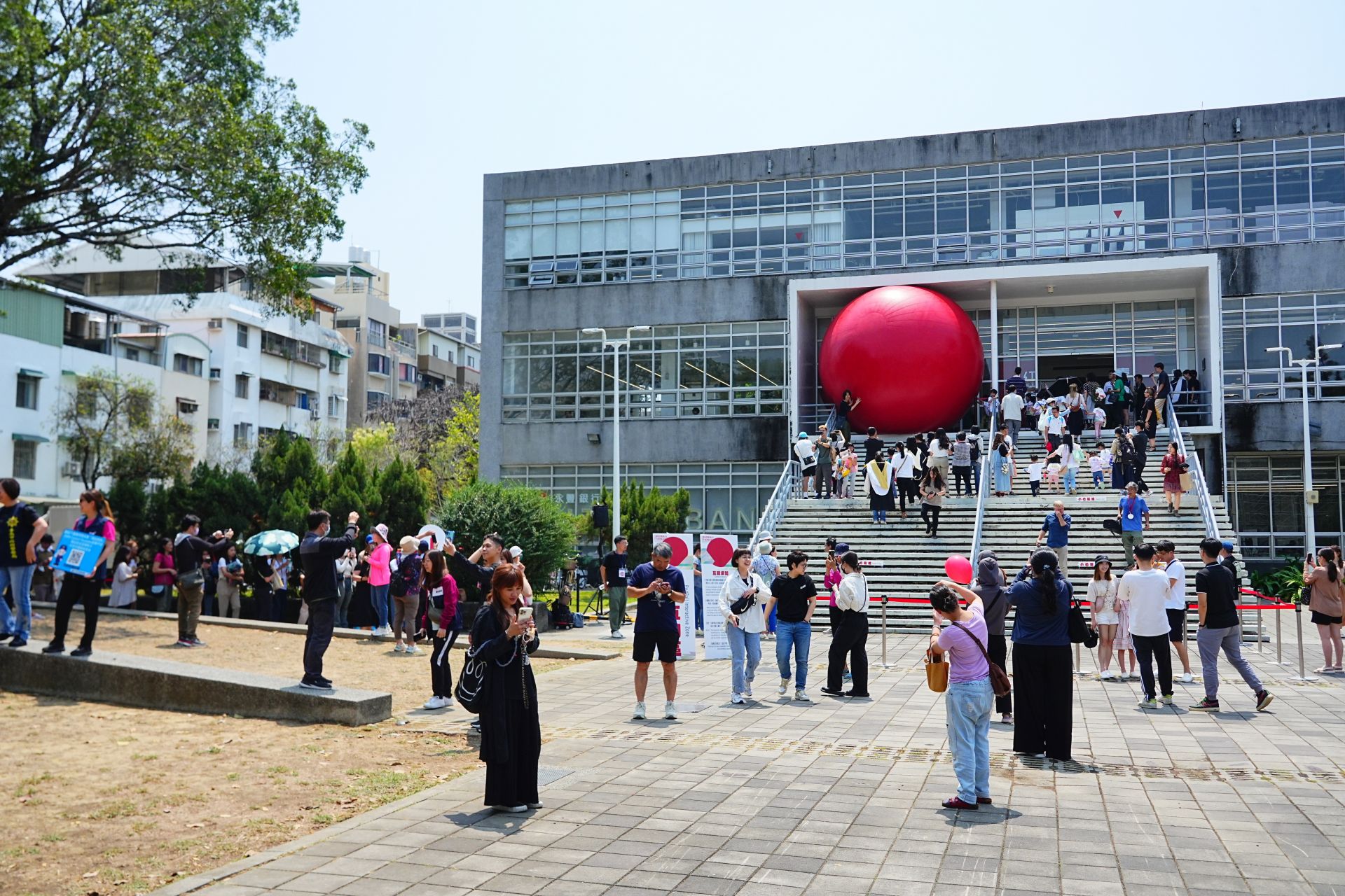
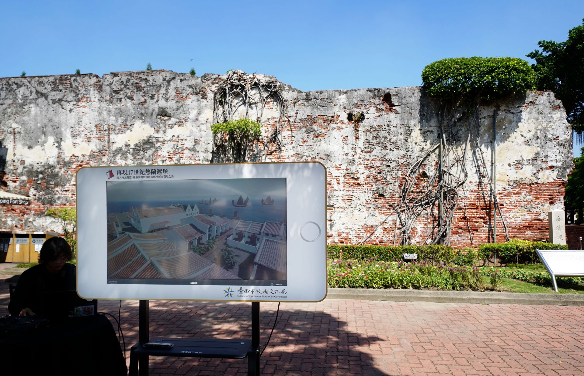
In addition to reconstruction research, Associate Professor Huang applied the virtual reality results of Fort Zeelandia and the township from the NCKU Museum to an outdoor AR augmented reality experience at the Fort Zeelandia Museum. Currently, there are three AR experience points set up at the museum's front plaza, observation deck, and the site of the round bastion, with an additional eight points to be completed by the end of the year. Through this AR system, the public can immerse themselves in the scale and appearance of Fort Zeelandia and its surroundings in the 17th century, compare them with existing remains, and gain a comprehensive understanding.
Historical investigations of Fort Zeelandia and the township in the past were limited to the Anping Old Fort area. In recent years, as part of the preparations for Tainan 400-related projects, the Tainan City Government collaborated with NCKU for relevant research projects and archaeological work. Professor Yi-Chang Liu's team from the NCKU Institute of Archaeology conducted excavations and research in areas such as Anping Shimen Elementary School, Anping Sword-Lion Square, and the vicinity of Anping Old Fort, discovering previously unidentified structures such as the outer wall and drainage system of Fort Zeelandia's outer fort and various architectural remains from the Dutch, Qing, and Japanese periods in Anping Sword-Lion Square. The updated permanent exhibition at the Fort Zeelandia Museum also features recent archaeological finds from the Fort Zeelandia and township areas, allowing the public to see the historical traces from the 17th-century Fort Zeelandia township to present-day Anping.
Minister of Culture, Che Shih, attended the opening ceremony of the updated permanent exhibition at the Fort Zeelandia Museum. Other attendees included NCKU Vice President and Museum Director Bing-Sheng Wu, Museum Deputy Director Wen-Sung Chen, Professor Yi-Chang Liu of the Institute of Archaeology, and Associate Professor En-Yu Huang from the Department of Architecture. After the opening ceremony, Che Shih and other dignitaries toured the indoor and outdoor exhibitions, using augmented reality (AR) to witness the appearance of Fort Zeelandia and the township 400 years ago. They also listened to explanations from Associate Professor En-Yu Huang while comparing the historical sites with present-day Anping.
Originally focused on the architectural history of South and Southeast Asia, Associate Professor Huang's interest in Fort Zeelandia was sparked in 2016 when he learned about the accidental discovery of the 1643 "Register of Real Estate in the Township of Fort Zeelandia" manuscript. This led him to delve into the reconstruction research of Fort Zeelandia's spatial layout. What started as a side project became increasingly intriguing, expanding into the reconstruction of Fort Zeelandia's architecture and other related studies, continuing to the present day.
According to Associate Professor Huang, the research team utilized historical documents such as the 1643 "Register of Real Estate in the Township of Fort Zeelandia," "Fort Zeelandia Diary," "Reports of the Dutch East India Company," "Grand Council Resolutions," and "Letters from the Governor of Taiwan to the Governor-General of Batavia." They also referenced various maps and architectural images from the Dutch colonial period, conducted on-site surveys in Anping, and visited Indonesia and the Netherlands to examine 17th-century architectural remains and spatial textures. After more than five years of effort, they successfully reconstructed the 17th-century layout and virtual model of Fort Zeelandia and the township.
Associate Professor Huang emphasized the challenges of the research, as the historical documents related to Fort Zeelandia were fragmentary and intricate. Additionally, the terminology for Dutch architecture in the 17th century varied, and the meanings of different architectural terms changed over time. Continuous discussions and consultations with scholars from the Academia Sinica and the Netherlands were necessary, even requiring visits to the Netherlands to gather clues. He shared a self-made "Explanation Table of Fort Zeelandia's Form, Structure, and Dimensions," stating that it took about half a year to create this concise document.
The development of Fort Zeelandia and the township in Anping reflected many traditional features of Dutch towns, such as the "grid pattern" spatial planning. According to Associate Professor Huang, this pattern originated from the flat terrain and the historical use of grid planning in polder areas since the late Middle Ages. The grid pattern is still recognizable within the original boundaries of the Fort Zeelandia township, while the spatial development beyond this area after the end of the Dutch colonial period is characterized by winding streets. Additionally, historical maps indicate that the Dutch, in efforts to reduce typhoon damage, constructed artificial shorelines using wooden stakes and stones and built canals in the township, reflecting the Dutch tradition of coexisting and resisting water.
The flourishing development of Fort Zeelandia township expanded from initially six blocks to 23 blocks. The township included businesses, blacksmith workshops, hospitals, a prison, and a cemetery. The 1643 "Register of Real Estate in the Township of Fort Zeelandia" revealed a diverse population cohabiting, with the majority being Han Chinese. Interestingly, the prison was located in the middle of the fort and township, suggesting a tense relationship between rulers and the majority of Han Chinese citizens.
In the reconstructed space of Fort Zeelandia township, compared to the present-day old neighborhoods in Anping, Associate Professor Huang pointed out that the current Xiaozhong Street corresponds to the former Breestraat, the Yanping Street was the former Kerkstraat, and the Zhongxing Street was the early Nauwestraat. He also speculated on the approximate locations of the public temple near Anping's Thng-sî-suann Cemetery, the Anping Guanyin Temple next to the second-generation public cemetery of the township, the Wenchu Temple near the former prison location, and the Miaoshou Palace near the former township hospital location. These subtle correspondences between past and present are fascinating.
In addition to reconstruction research, Associate Professor Huang applied the virtual reality results of Fort Zeelandia and the township from the NCKU Museum to an outdoor AR augmented reality experience at the Fort Zeelandia Museum. Currently, there are three AR experience points set up at the museum's front plaza, observation deck, and the site of the round bastion, with an additional eight points to be completed by the end of the year. Through this AR system, the public can immerse themselves in the scale and appearance of Fort Zeelandia and its surroundings in the 17th century, compare them with existing remains, and gain a comprehensive understanding.
Historical investigations of Fort Zeelandia and the township in the past were limited to the Anping Old Fort area. In recent years, as part of the preparations for Tainan 400-related projects, the Tainan City Government collaborated with NCKU for relevant research projects and archaeological work. Professor Yi-Chang Liu's team from the NCKU Institute of Archaeology conducted excavations and research in areas such as Anping Shimen Elementary School, Anping Sword-Lion Square, and the vicinity of Anping Old Fort, discovering previously unidentified structures such as the outer wall and drainage system of Fort Zeelandia's outer fort and various architectural remains from the Dutch, Qing, and Japanese periods in Anping Sword-Lion Square. The updated permanent exhibition at the Fort Zeelandia Museum also features recent archaeological finds from the Fort Zeelandia and township areas, allowing the public to see the historical traces from the 17th-century Fort Zeelandia township to present-day Anping.
A large-scale AR installation set up in front of the opening Fort Zeelandia Museum allows the public to envision the appearance of the area 400 years ago.
Assistant Professor En-Yu Huang conducts research in Indonesia.
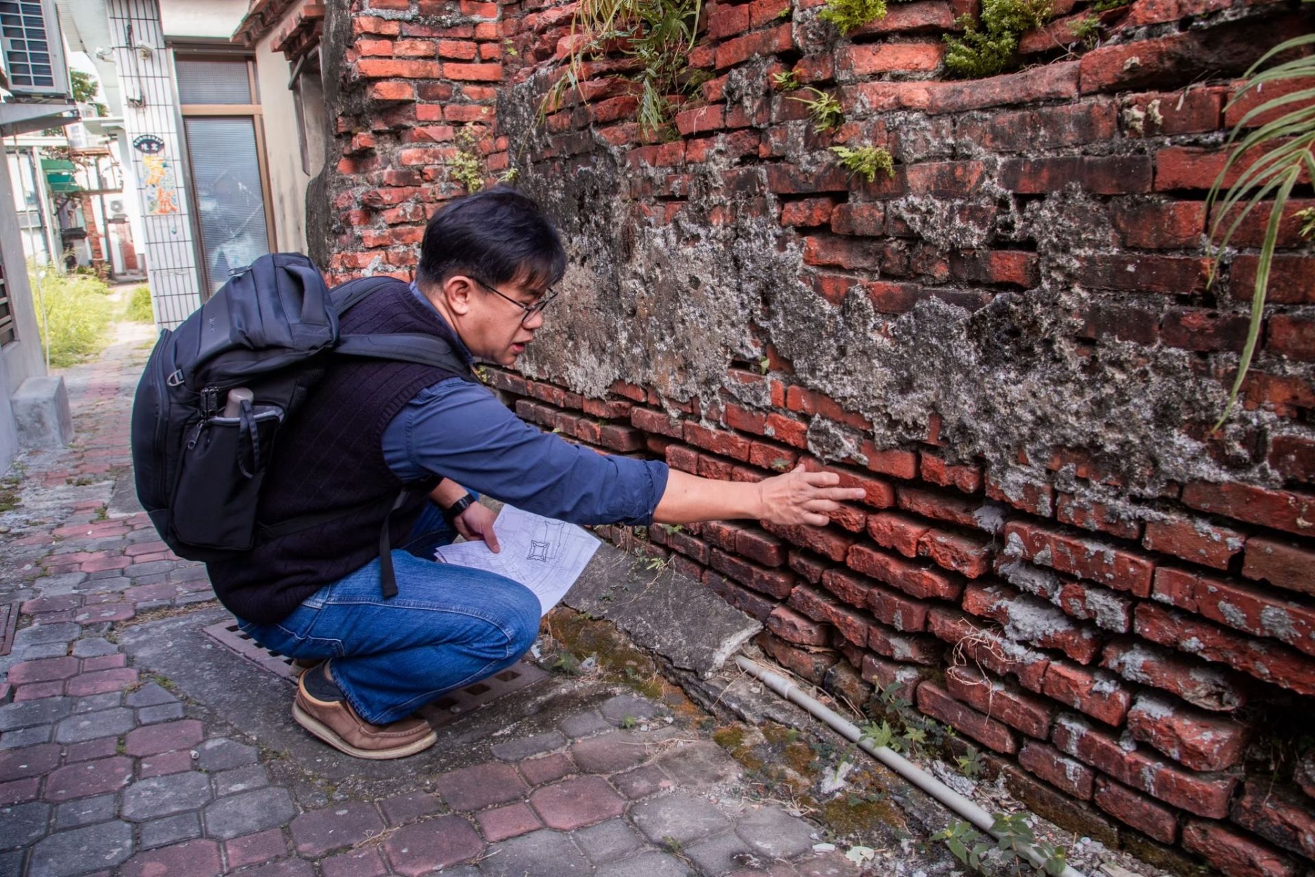
Dr. Huang frequently visits Anping to conduct surveys and on-site investigations for the reconstruction of the urban space of Fort Zeelandia.
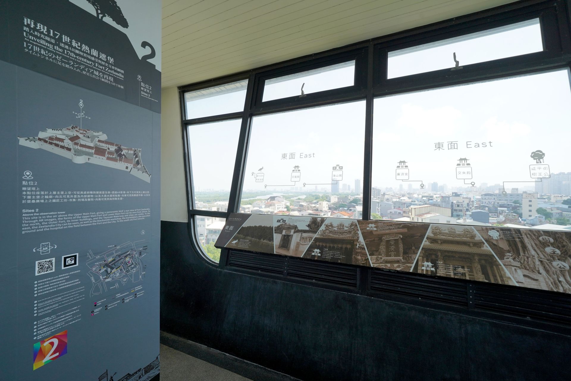
The AR points on the lookout tower allow visitors to compare the past and present with the assistance of technology.
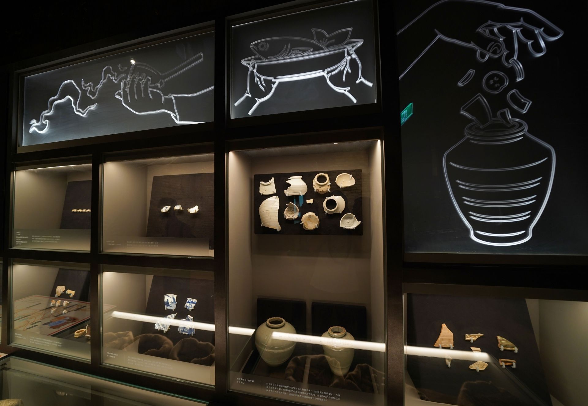
Archaeological artifacts displayed in the Fort Zeelandia Museum.